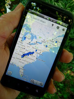
 I thought it would be cool if I could put a map on here that showed my progress as I hiked the Appalachian Trail. I started looking to find a way to create a map that could be embedded in the blog, and update it by placing a waypoint at my current position each day, using my Android smart phone.
I started exploring Google Maps on my PC, and found My Places with a big red Create Map button. So I pushed that button, and started placing waypoints along the trail. Mostly at places like significant road crossings, highly regarded hostels, festivals, etc. Then I found the link button, and created a link that could be embedded in a web site. I fired up Blogger, and created a special page for this map. (You can see it listed over there in the right-hand column.) Every time I added a new link, it was updated on the blog page.
Beautiful ...
Then I opened Google Maps on my droid. I had to geek a bit to find My Maps hidden under the Layers button in the upper right corner. I got a pop up listing the map I had created, and when I punched it, I got the map with all the waypoints I had entered.
Beautiful ...
But that's when the frustration started. I couldn't find any way to set a waypoint based on coordinates provided by the phone's GPS. I checked every menu, googled it, spent way too much time sifting through forums, saw a reference to a My Maps app that apparently no longer exists. Tried Latitudes and starring locations, but they wanted to go to street adresses near the point selected. I finally I got a definitive response from a Google Maps Forum guy - It can't be done. But he'll be glad to forward my suggestion to the developers so they can maybe implement it someday ...
 %@&$#*!
A week or so goes by, and I'm dropping comments in every forum that is mildly related to Google Maps. A Google Community Manager on Google+ posts about how "we all heart My Maps," and I made a mildly snarky comment about how I'd heart 'em a lot more if I could place a waypoint using my droid. Kristian Serrano engaged me in a discussion of my requirements, and suggested using the My Tracks app.
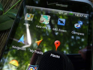
I had been using My Tracks to measure hikes and bike rides, but hadn't noticed the Marker function in the menus. It was greyed out, and I had to start recording a track to use it. I was then prompted to gave the marker a name, and enter a description. I saved it and stopped recording the track. I brought up the menu, selected send to Google | Google My Maps | Pick an Existing Map | Send Now, I selected my map, and voila! The waypoint was on my map embedded in this blog. A bit of a workaround, but I was able to place a waypoint based on coordinates using my Droid!
Success!
Here's the process in detail (Android):
Oct 8, 2012 Note: While hiking last summer, the My Tracks app was updated, and the process became a lot more intuitive. I've updated the following based on the latest release.
- Open My Tracks
- Press the big red button to begin recording a track
- Press your phone's menu button and select Insert Marker
- Give the marker a name, type and description
- Press Add
- Press the big gray button to stop recording the track
- Give the track a name, type and description if you want, and press Save
- Press your phone's menu button
- Select send to Google, then check Google Maps and Use existing Map
- Press Send now
- Select the map you want from the list that comes up.
- Your track and waypoint will automatically upload, and appear on your map
I've been using this process to update my location as I hike the trail. If you have a good data connection, you'll see the map, or sat photo, and be able to upload the track and waypoint to your map. If you don't have a data connection, you can still create and save tracks/waypoints, and upload them later. You just won't see a map.
Follow me as I continue to hike the Appalachian mountain range. Subscribe to my blog by filling out the Follow By Email form in the right-hand column, and you'll be notified when we post a new entry.
"I have an existential map. It has 'You are here' written all over it." - Steven Wright

This is great, Bill! I've had similar trouble figuring out how to do just this. You saved me a ton of work! Will you do your thru on 2012 or 2013?
ReplyDeleteI begin mine in 4.5 months. Good luck to ya, and thanks again!
Looks like we may be sharing the same piece of trail. Hope to see you out there!
ReplyDeleteExcellent. I reach Springer March 13. Good luck on your journey!
ReplyDeleteI'm a week behind you. maybe we'll catch up ... But I doubt it!
ReplyDeleteOutstanding information. I've been trying to figure out how to do the same thing. I already have "My Tracks" on my Droid. I'll test it out tomorrow. Cya on the trail.
ReplyDeleteHi Bill,
ReplyDeleteMe again. I just got my Android phone and your tutorial was extremely helful. I thought I understood everything but I am unable to upload data from My Tracks to one of my Google Maps. In fact, none of my maps even show up when I select Google >> Google My Maps >> Pick an Existing Map. Do I need to do something to my Google Map to make it accessible by My Tracks? Thanks for the help!
Chris, I don't remember having to do anything to connect the two. I do have my map set to public, but I don't know if that makes any difference.
DeleteI did see where there is a counter-intuitive step. Once you select Google >> Google My Maps >> Pick an Existing Map, you have to press Send Now. You should then be presented with a list of your maps from which to choose.
I played with it tonight, and updated the post above with a step by step process. Hope this helps